OpenLR™ is a standard for handling map locations.
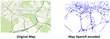
It is designed to transfer location information between different traffic management systems, using dissimilar maps. The encoded locations are typically specific road stretches, lists of connected roads, point locations or areas.
OpenLR™ allows users to read data from Flows without knowing the internal network representation used by Flows.
In the Street Forecast API context, a forecast result is labeled with an OpenLR code for every single street of the network.
Example:
streetForecast {
 id: 52920
 fromNode: 894
 forecast {
   start {
     seconds: 1700831364
   }
   end {
     seconds: 1700831400
   }
   speed_valid: true
   speed: 83.110725402832031
   timezone: "UTC"
 }
 forecast {
   start {
     seconds: 1700831400
   }
   end {
     seconds: 1700832000
   }
   speed_valid: true
   speed: 83.88555908203125
   timezone: "UTC"
 }
 forecast {
   start {
     seconds: 1700832000
   }
   end {
     seconds: 1700832600
   }
   speed_valid: true
   speed: 85.318397521972656
   timezone: "UTC"
 }
 forecast {
   start {
     seconds: 1700832600
   }
   end {
     seconds: 1700833200
   }
   speed_valid: true
   speed: 85.942306518554688
   timezone: "UTC"
 }
 openLRcode: "CwlJ3yeJ8AEWc+kX8dgBbOcS"
 }
As you can see, in the example there is a street identified by:
- id: 52920
- fromNode: 894
...and labeled with OpenLRcode CwlJ3yeJ8AEWc+kX8dgBbOcS.