KPI instance
A KPI instance is described by a set of attributes:
KPI identifier: unique alphanumeric string associated to a KPI instance.
Example: "kpiId": "a5c22445-8592-430b-b36b-01d265a996d0"
- KPI name: string associated with a KPI instance.
- KPI parameters
A KPI instance is characterized by a status:
- OK: the KPI value is not in the WARNING and CRITICAL zone.
- WARNING: the KPI value is in the WARNING zone defined by the thresholds values
- CRITICAL: the KPI value is in the CRITICAL zone defined by the thresholds values
A KPI is also associated to a location, and the location is associated to a shape.
Thresholds
Threshold values are associated to a KPI instance.
They are expressed as couples of numeric values (the WARNING and the CRITICAL thresholds), representing the limits of the KPI value.
KPI values can be considered in two different directions:
- INCREASING (the higher KPI values are associated with the better quality of the KPI)
- DECREASING (the lower KPI values are associated with the better quality of the KPI)
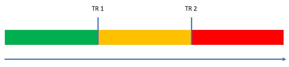
For an INCREASING KPI it is possible to distinguish:
- Critical (RED): if the KPI value crosses the second threshold TR2.
- Warning (YELLOW): if the KPI value falls in-between the first and the second threshold (TR1 and TR2).
- Normal (GREEN): if the KPI value is smaller the first threshold TR1.
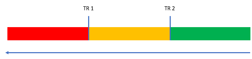
For a DECREASING KPI it is possible to distinguish:
- Critical (RED): if the KPI value is smaller than TR1.
- Warning (YELLOW): if the KPI value falls in-between the first and the second threshold (TR1 and TR2).
- Normal (GREEN): if the KPI value is greater than TR2.
For additional details, see KPI use case.
Location
A location refers to a spatial object related to the underlying network.
It aggregates several elements of the network in order to manage/export related data in an efficient way.
Furthermore, it must be associated with a location name provided by the user during the creation of the location.
Currently, only one location type is available:
- Area: it is a set of streets (or links) intersecting or included in the area, and the associated shape is provided by the user.
- Path: it is an ordered sequence of streets (or links) (a path can be a single link as well), and the associated shape is the ordered union of all street shapes.
- Turn: it is an ordered sequence of 2 streets, and the shape is the ordered union of the 2 street shapes.
- Oriented Point: it can be optionally map matched on a directed street bearing, and the shape is a point
Shape
A KPI is associated to a location, that is associated to a "shape".
The shape define the specific geografic boundaries of a location.
The building of a shape is based on the format Well Known Text (WKT).
Each WKT object follows a fixed structure. The most common structures are:
- Point: POINT(10 40) — Represents a single X and Y position separated by a space.
- Line: LINESTRING(0 0, 20 40, 20 80) — A series of connected points, separated by commas.
- Polygon: POLYGON((0 0, 20 10, 20 30, 10 20, 0 0)) — A closed area. Note that the first and last points must coincide to close the figure.
For additional details on the WKT format, see here.